
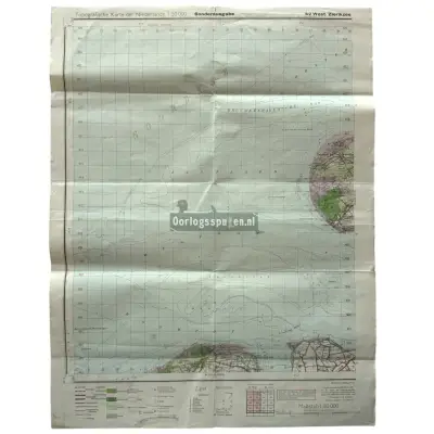
Photo from Oorlogsspullen.nl — full gallery at the dealer ↗
NEW on MilitariaRadar since 2026-11-19
Listing no. 130532
WWII German 'Topografische Karte der Niederlande' staff map of West Zierikzee
Dealer’s title: Original WWII German ‘Topografische Karte der Niederlande’ staff map of West Zierikzee
€35
dealer’s price: €35
· ≈ £29.27 · ≈ $38.48 · converted at the National Bank of Poland average rate (table 225/A/NBP/2026) of 19.11.2026 · shipping cost: unknown · change the currency at the top of the page
Available according to the dealer
· checked 1 day ago
 Buy from Oorlogsspullen.nl
You buy directly from the dealer, on the dealer’s terms. MilitariaRadar does not sell anything and does not handle payments.
Item facts
| Category | not yet classified | automatic identification |
|---|---|---|
| Type | not identified | — |
| State / formation | Germany 1933–1945 (Third Reich) | automatic identification |
| Period | WW2 (1939–1945) | automatic identification |
| Maker | not identified | — |
| Maker’s mark | not identified | — |
| Dealer’s category | Papierwerk - Paperwork | dealer |
| Dealer and country | Oorlogsspullen.nl · NL | dealer profile |
Dealer’s description
excerpt, in the original languageOriginal German ‘Topografische Karte der Niederlande’ staff map of West Zierikzee from 1941 used during the Second World War.This military map concerns sheet ‘42 West Zierikzee’ and was issued as a ‘Sonderausgabe’ in scale 1:50.000.The map depicts parts of Schouwen-Duiveland, Noord-Beveland and Wal…
In English Sheet '42 West Zierikzee', issued as a Sonderausgabe at 1:50,000 scale and dated 1941. The map depicts parts of Schouwen-Duiveland, Noord-Beveland and Walcheren. summary prepared automatically – may contain errors; the dealer’s description is what counts
Translated automatically by your browser – may contain errors.
Price history of this listing
2026-11-19€35 (first seen)
Since first seen on MilitariaRadar, in the dealer’s currency.
Oorlogsspullen.nl
NL · 1,473 active listings
Dealer profile ›